Behind the ancient towers of the Duke of Northumberland's home are the unique Revolutionary War battle maps of the general who saved the British from disaster at Lexington
-
August 1969
15 years ago By admin Volume20Issue5
 We stood beside the billiard table in a richly beautiful room in Alnwick Castle, hesitating for a moment before opening the great portfolio which the Duke of Northumberland had laid out for us. On the walls shone the mellow beauty of Titians and Tintorettos. Outside the high windows the great park rolled upward to the hills of the border country. The Duke spoke encouragingly. “My ancestor was one of the commanders of the British troops in Boston in 1775,” he said. “He liked maps. His collection has been here in a black box ever since he came home, until I put it into this portfolio. Do you care to look at it?”
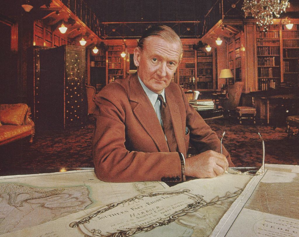
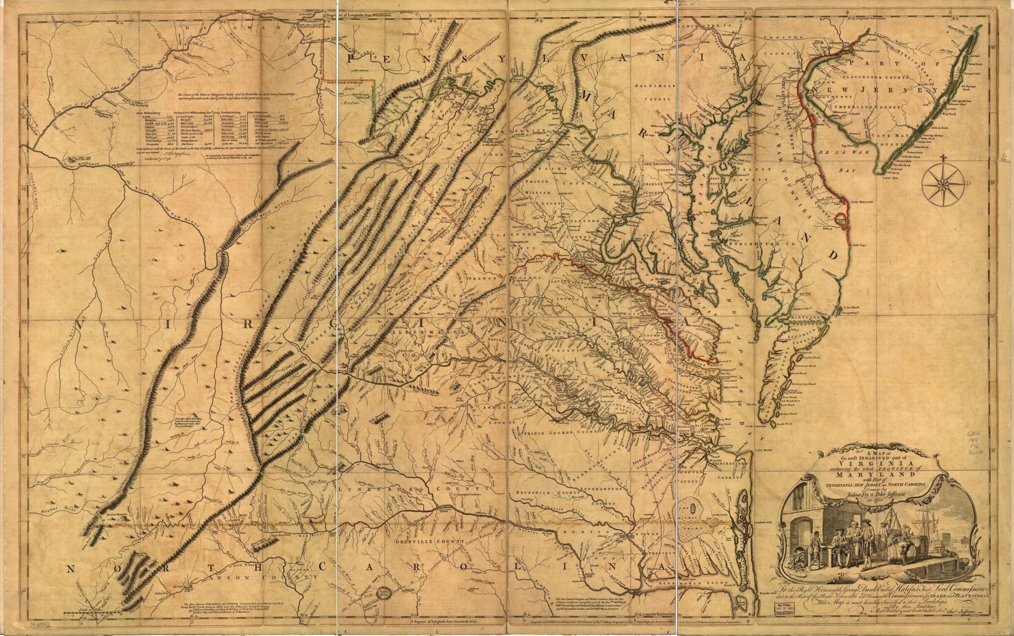
In the billiard room His Grace said, “There, that’s the 1751 map of Virginia.” There it was indeed—the third known copy of the first edition of the famous Fry-Jefferson map. It was quickly apparent that the Duke shared our excitement. After this he took us into his library, a room of noble proportions with the soft amber bookbindings rising to a great height and a small, graceful balcony dividing them halfway up. “Help me lift this portfolio,” said the Duke. “This is the map collection of Hugh, Earl Percy, who was in America from 1774 to 1777. It has never been properly listed; perhaps you could do it for me. Let’s put it on the table.”
We opened the great folio and began turning over the maps. There were more than fifty, most of them manuscript originals of the terrain of battles and engagements of the American Revolution, many drawn on the day of conflict or shortly after. The signatures of John Montresor, Claude Joseph Sauthier, and Thomas Page, whom we knew to be among the finest surveyors and draftsmen of the Revolutionary era, caught our attention. A sketch of Bunker Hill and Charlestown Neck as seen from Beacon Hill, with British entrenchments and “Rebel Redoubt,” had apparently been made during the bloody storming of Breed’s Hill.
There was a map of New York showed Fort Washington, surveyed on the very day that Percy led his troops in the capture of that fort. This was history in the making.
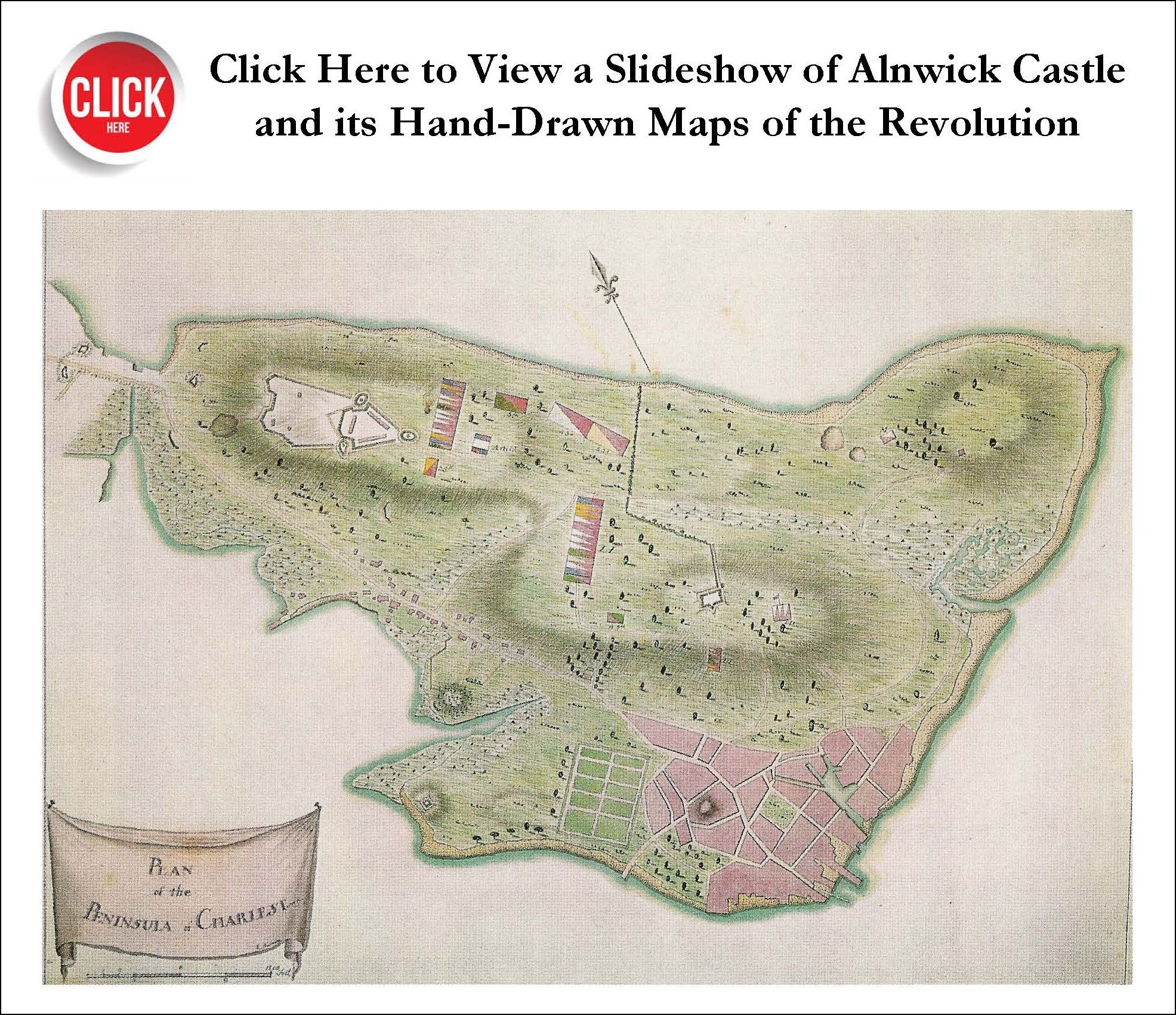
Then we came upon a small map of Boston and its vicinity which showed in color various positions of troops along the road leading to Lexington and Concord, with accompanying legends: “Bridge where the attack began,” indicated by two red lines across a stream; the positions of rebel “militia”; “Col. Smith’s return from Concord”; “Lord Percy’s return from Lexington”; and at the bottom of the sheet, “19th April 1775.”
William said to the Duke, “Every American schoolboy knows a poem beginning:
Finding this is for an American historian like an Englishman’s finding a manuscript map of Hastings dated October, 1066, made for William the Conqueror.
“The American Revolution—the United States—began here.”
“Yes, I know,” the Duke said; “several years ago with an American friend I walked over the field of action of that day.” The part that his ancestor Hugh, Earl Percy, played in the events of April 19, 1775, was a crucial one, characterized by a coolness and intelligence that stood in marked contrast to the almost comic bungling of the rest of the British command. Late on the night of April 18, in a conversation with eight or ten gentlemen of the town on Boston Common, Lord Percy had heard that a contingent of royal troops had left Boston for Concord to capture the arms and ammunition there. The expedition, Percy knew, was supposed to be secret, and he hurried to General Thomas Gage, commander in chief of the British army in America, to tell him that the news was all over town. Gage was astonished: even the commander of the expedition, Lieutenant Colonel Francis Smith, did not yet know his destination, for his orders were sealed. Someone, Gage said to Percy, must have betrayed his confidence. No one had, but every British troop movement, every order or conversation overheard, was being noted by the Boston patriots, one of whom was Paul Revere.
Delays meanwhile slowed the execution of Gage’s plan for a secret night march to Concord. On the opposite bank of the Charles River from Boston, Lieutenant Colonel Smith, old, obese, and ponderously slow, waited with his troops until almost two o’clock in the morning for additional supplies to be ferried over to him. With him was Major John Pitcairn of the Royal Marines. At last the troops got under way, wading through a ford up to their middles. By 6:00 A.M. Gage, disturbed by a messenger from Smith who reported that the country was aroused, sent orders that Percy’s brigade with Pitcairn’s marines should march to cover Smith’s return. The brigade received its orders at seven and by half past seven had assembled, with two cannon and supply wagons. Percy was ready; but where were the marines? Gage’s order, addressed to Pitcairn, was lying unopened on the Major’s desk.
By eight thirty the battalion of Royal Marines assembled without their major, and at quarter to nine Percy’s column marched along Orange Street and across Boston Neck toward Lexington and Concord.
Percy found an ominous sign of rebel activity when he reached the Brighton Bridge, a simple structure that spanned the Charles at Cambridge: the boards had been removed. But the local committee of safety had frugally piled them on the Cambridge bank; Percy sent some of his men across on the string-pieces of the bridge and they soon relaid the boards. The brigade was on its way again, with its two six-pounders. At Cambridge, Percy, confused by the numerous roads leading from the common, asked the only individual he could find in the apparently deserted town for directions to Concord. It was a tutor of Harvard College, Isaac Smith, who “could not tell a lie” and pointed the way. (For not having sent the troops to the marshes by Phipp’s Farm, Smith’s neighbors made his life so unbearable that he fled to England. Years later he returned and became Harvard’s librarian.)
For Percy now, action lay only a’ few miles ahead. He and his men met the retreating troops of Colonel Smith on the eastern outskirts of Lexington, formed a square to receive them, and gave them refreshments. “They were so much exhausted with fatigue,” wrote a British officer with Percy, “that they were obliged to lie down for rest on the ground, their tongues hanging out of their mouths, like those of dogs after a chase.” Percy’s own rough draft of his report to General Gage gives a vivid account of the events of the day. Part of this account, now with the Percy papers in Alnwick Castle, follows.
April 20, ’75
Sir: At Menotomy, I was informed by a person whom I met that there had been a skirmish between his Maj’s troops & the rebels at Lex n , & that they were still engaged. On this, I immediately pressed on, & in less than 2 miles we heard the firing very distinctly. About this time (which was between i and 2 o’clk in the aft n ) I met with L t . Gould of the King’s Own Reg, who was wounded, & who informed me that the Gren s & L[ight] I[nfantry] had been attacked by the rebels about daybreak, & were retiring, having expended most of their ammunition: & in about a quarter of an hour I met them retiring thro’ Lex n . I immedly ordered the two field pieces to fire at the Rebels. … The shot from the cannon had the desired effect. … In this manner we retired for 15 m. under an incessant fire all round us, till we arrived at Cha s town, wh road I chose to take, lest the rebels shd have taken up the bridge at Cambridge (wh I find was actually the case), & also as the country was more open & the road shorter [than by Brighton, Roxbury, and Boston Neck]. During the whole of our retreat, the rebels endeavored to annoy us by concealing themselves behind stone walls & within houses, & firing straggling shot at us from thence ...
Percy’s common sense and military judgment saved the British regulars from disaster on that galling April day. His decision to bypass the bridge across the Charles and turn off on another, more northerly route to Charlestown undoubtedly saved his own command—and Colonel Smith’s exhausted men—from heavy losses. How did Percy know this road? He may have had in mind the information on a crude pencil sketch of the area (page 28), which we found in the portfolio and which shows such a road.
For Percy himself the events of the day and the spirit shown by the rebels came as a severe shock, for in common with other officers and those in the government in England, he had regarded the colonials as poltroons. On the day after the retreat from Lexington he wrote in a personal letter,
Whoever looks upon them as an irregular mob, will find himself much mistaken. They have men amongst them who know very well what they are about, having been employed as Rangers agst the Indians & Canadians, & this country being much cov d w. wood, and hilly, is very advantageous for their method of fighting. Nor are several of their men void of a spirit of enthusiasm, as we experienced yesterday, for many of them concealed themselves in houses, & advanced within 10 yds. to fire at me & other officers, tho’ they were morally certain of being put to death themselves in an instant. … They are determined to go thro’ with it, nor will the insurrection here turn out so despicable as it is perhaps imagined at home. For my part, I never believed, I confess, that they wd have attacked the King’s troops, or have had the perseverance I found in them yesterday.
Percy’s own position in the months before that April day had been difficult. As a member of the House of Commons from Westminster, his opposition to those very measures that were arousing the resentment of the American colonists was well known to his constituents; and in this attitude he followed the views of his father, the Duke of Northumberland, who had opposed the Stamp Act and the Tory party’s colonial policy. As an officer in the Royal Army, however, Percy believed that it was his duty to suppress by force any rebellion against the king’s government and decrees.
His assignment to Boston, the most intransigent city in America, had been a diplomatic maneuver by Lord North’s Tory government to charm and impress the colonists by the presence of a young man of personal attractiveness, liberal views, and noble family. On July 4, 1774, Percy’s transport arrived off Boston Harbor from Kinsale, Ireland, where his troops, the 5th Foot, had embarked on May 17. The next day the regiment landed at Long Wharf and marched through the streets to their encampment on Boston Common. “The Shiners,” a name given to the 51)1 because of their extreme polish and attention to dress, made a fine show: the coats of the soldiers were faced with gosling green, and the officers were resplendent in scarlet and gold; above them flew the green silken flag of the regiment with the figures of Saint George and the dragon above the motto “ Quo fata vacant.”
Percy was delighted with the land, “the most beautiful country I ever saw in my life.” He wrote to his father after a month, “It is, as far at least as I have been round this town, most delightfully varied. The hills, rising from the valleys by gradual & gentle ascents, interspersed everywhere with trees, give it a most agreeable appearance.”
Across the street from his camp on Boston Common, Lord Percy chose for his quarters one of the mansions of the city, a fine wooden house surrounded by wide lawns on the northerly corner of Tremont and Winter streets. It was the property of John Williams, an inspector of His Majesty’s customs in Boston. Soon after Percy’s arrival he wrote that he had acquired
a good house to dine in (for we are all obliged to remain at oilier times & sleep in camp). By this convenience I am enabled to ask the officers of the Line, & occasionally the Gentlemen of the country, to dine with me; & as I have command of the Troops here, I have always a table of 12 covers every day. This, tho’ very expensive, is however very necessary.
Even in Boston, Percy’s courtesy, justice, and liberality made him grudgingly respected. Not only did he entertain Boston gentlemen in his house; he made himself agreeable in other ways: sending his compliments to a merchant’s wife on the excellence of her landscape drawings, or offering immediate assistance to a family made homeless by a fire. Though he was a stern disciplinarian, he was at the same time considerate of his officers and men and of their families. Later, after he returned to England, this statement was published in the Independent Chronicle of Boston:
It is impossible to express the regret of the army on the departure of Lord Percy. Provincials as well as our own people, if in distress, shared alike in his benefactions. He kept open table for inferior officers. In short, he spent while in America ten thousand pounds of his own fortune, all his pay, and upwards of twenty-five thousand pounds remitted to him by the Duke and Duchess.
As we continued to turn over the sheets in the portfolio, we found a chart of Dorchester Heights, where Washington’s brilliant fortifications, constructed under cover of darkness, forced Gage’s successor, General William Howe, to evacuate Boston. And there were maps of Percy’s later movements and campaigns. On March 17, 1776, he sailed with Howe from Boston tor Halifax but returned with him to Staten Island that July; now a lieutenant general, he was given command of one of the three great divisions of the British army, fought with success in the Long Island campaign, and led his division in the thickest of the fight to capture Fort Washington. There, as on his return from Lexington, his horse was shot under him. In December, with General Henry Clinton, he took Newport and remained as commanding general of Rhode Island. During this campaign his mother died; from her he inherited the titles and estates of a half dozen baronies and became a peer of England in his own right. As a result of a vigorous disagreement with General Howe, who demanded troops that Percy felt could not be spared from his own precarious position, he asked for a recall. He sailed from Newport on May 5, 1777, never to return to America. On his departure the townspeople of Newport presented him with a formal address in which they praised him for “that unbounded and well-directed Generosity which has so often procured for your Excellency the blessings of those who were ready to perish.”
This was the man whose maps had lain so long untouched in a black box and were now spread before us. The day wore on in the billiard room at Alnwick Castle as we went on recording the information needed to make the cartographical listing of Earl Percy’s maps which we had promised the Duke. Our excitement deepened as the value and significance of the collection became more and more apparent. His Grace kept coming in to share our discoveries. So did other, younger members of the family. “I have six children,” said the Duke, “and they are all at home for the Christmas holidays.” The Duchess, wearing a sweater and a short skirt, also came to see what we were doing; we had seen her picture in the library, as a graceful lady-in-waiting to Queen Elizabeth II. Once, the huge oak portal burst open and a handsome, blond, teen-age boy dashed into the room. “Harry,” said his father with vigor, “don’t you ever shut a door?” For a breathless moment, there was young Harry Percy himself, whom Shakespeare’s Prince Hal had called “the Hotspur of the North; he that kills me some six or seven dozen of Scots at a breakfast, washes his hands, and says to his wife, ‘Fie upon this quiet lifel I want work!’ ”
About noon, His Grace appeared with a bottle of sherry and three glasses and said, “Sit down a little and let us talk.” He wanted to know about our background, and he spoke readily about his own war experience, his trips to America, and other matters. He told us about his estates in Northumberland, and those surrounding Syon House, the beautiful country house near Isleworth on the Thames, first occupied by a Northumberland in 1553 and redone in the eighteenth century by the great architect Robert Adam; this the Duke promised to open for us for map hunting. Clearly this man possesses a historical imagination and a keen understanding of his extraordinary heritage. And yet, he is a man of the present day, valuable to modern England. He is the first chancellor of the recently founded University of Newcastle. Under his direction, part of the gardens of Syon House have been made into a center where any Englishman can come to see methods and experiments in gardening, receive instruction, and buy plants. And shortly after our conversation he accepted the chairmanship of the royal commission to make an exhaustive study of the hoof and mouth disease that decimated the herds of England during the winter of 1967-68.
Afternoon shadows lengthened as we followed Lord Hugh Percy’s American Revolutionary progress; maps of Boston gave way to those of Canada, of Staten Island, of Fort Washington, and finally of Newport, whence he had returned, making a full report to the king at Kew before he came to visit in this very house. About five o’clock the Duke rejoined us. “You must be very tired,” he said. “You ought to have some tea.” He introduced us to his children; an older daughter joined us for family tea with the younger ones. Then he took us to see the rooms, pictures, china, and furnishings in his castle that he himself likes best.
Next morning we finished the Earl Percy collection and worked in the library attempting to decipher the American place names on a white vellum map of the world made in 1616 by Edward Wright for the ninth Earl of Northumberland, the “Wizard Earl,” then imprisoned in the Tower of London. Sir Walter Raleigh had been in the Tower too, and had used this map in planning his last voyage, to Guiana.
“I have to go hunting with Harry tomorrow,” the Duke had said when we asked if we might use morning light to study it, “but I’ll tell you what we’ll do: I’ll hide the keys to the case under this cloth, and you put them away here when you finish.” Next morning he came in in his riding habit to check on our progress and to say good-bye. His final kindness to us was his permission for this reproduction of Earl Hugh’s maps.