After the French and Indian War, Britain reimagined North America and created hundreds of maps to bring about that vision after having gained vast new territories.
-
Special Issue - George Washington Prize 2018
8 years ago By Edwin S. Grosvenor Volume63Issue2
During negotiations to end the Seven Years’ War, Great Britain’s diplomats used the leverage that came with conquests in Canada, India, Africa, and the West Indies to gain large territorial cessions from France and Spain. After the terms of the Peace of Paris went into effect on February 10, 1763, colonial British America extended from Hudson Bay to the Florida Keys, from the Atlantic coast to the Mississippi River, and across the Caribbean—at least on paper.
After the ink had dried on the treaty, the king and his Privy Council charged the Lords Commissioners of Trade and Plantations (commonly known as the Board of Trade) to propose a system for managing Britain’s new dominions. In response, the Board of Trade put forward a detailed plan for the new territories’ occupation, development, and defense. It called for settlement across the mainland’s coastal plain and in the islands, command over coastal and Caribbean navigation, and a limit to colonization in the North American interior. More ambitious yet, the Board’s plan described how settling these acquired lands in improved ways would reshape British America as a whole to better secure its dependency.
To support this initiative, it called for the comprehensive mapping of British America, beginning with new surveys of the edges of this enlarged empire to affirm possession of long-contested frontiers, accumulate strategic knowledge in anticipation of future French and Spanish intrigues, and implant self-sustaining settler societies. From 1763 to 1775, agencies of the imperial state worked within the parameters of the Board’s plan to secure these scattered places, dispatching surveyors to mark new boundaries, lay out forts, chart coastlines, and divide the land for settlement. Commanded to map these new territories to rigorous scientific standards, the surveyors brought the resources of a rising global empire to bear on the task of better understanding American lands and waters. They documented their discoveries with ink and paper, composing maps in the field and dispatching them to London to report on the progress of this mission to prepare American spaces for intensive, regulated colonization. The hundreds of manuscript maps produced by these surveyors in the 1760s and 1770s describe British America transformed. This book explains the vision behind this vast project of improvement, the expeditions it set in motion, and the meanings of the images these geographic surveys produced in the generation before the American Revolution.
Across five zones—the Gulf Coast, the maritime northeast, the trans-Appalachian interior, peninsular Florida, and the southeastern Caribbean—surveyors examined places that, with the notable exception of the colonial frontier with Native North America, historians have seen as marginal to the history of early America. Their mission was to fill a prospective cartographic archive in the imperial metropole that could describe America comprehensively. The Commission for the Sale of Lands in the Ceded Islands surveyed Dominica, St. Vincent, Grenada, and Tobago to accelerate the division and sale of plantation tracts as part of a larger scheme to expand slavery, revenue, and security in the British West Indies.
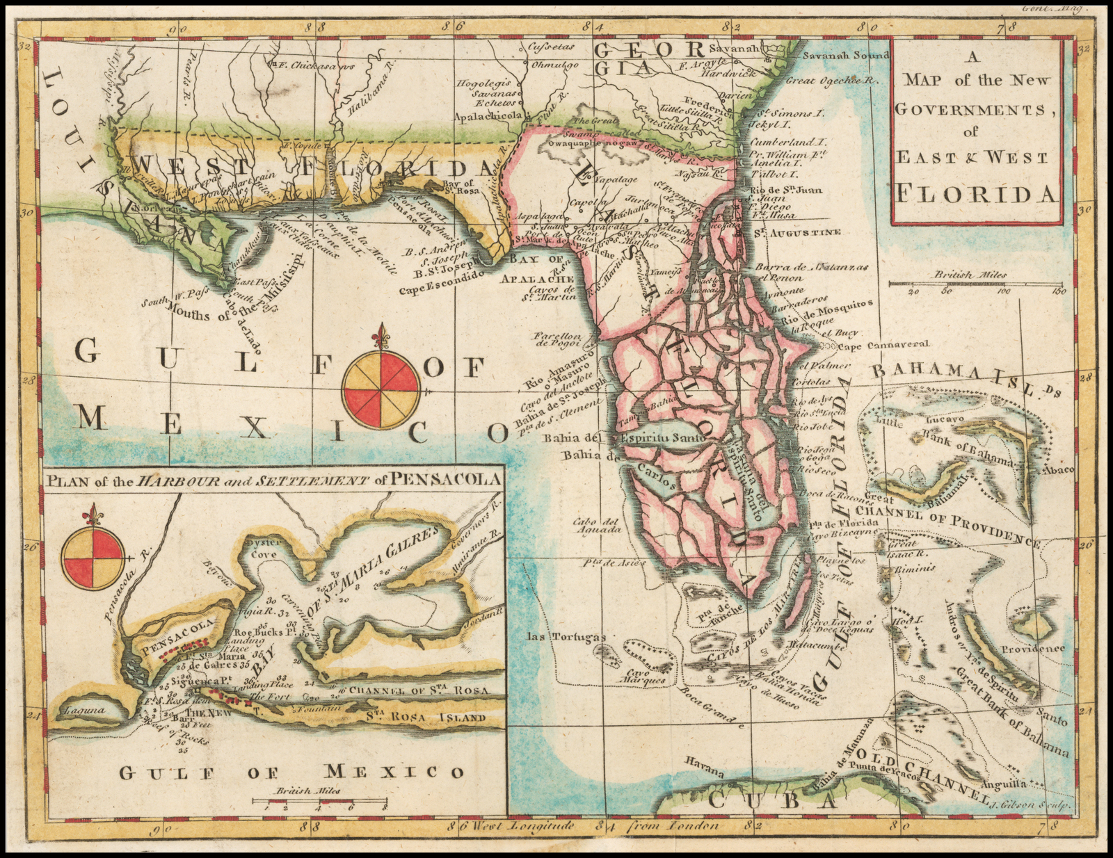
For more than a decade following the Royal Proclamation of 1763—George III’s order to establish new colonies and regulate land grants in the acquired territories—Britain’s superintendents of Indian affairs convened congresses with indigenous spokesmen to determine the specific location of an Indian boundary line, which promised to regulate commerce and settlement in the interior. The General Survey of North America, along with Admiralty and army surveying expeditions, worked to promote colonization; preserve resources; and open strategic areas to scrutiny in Quebec, the Gulf of St. Lawrence, Nova Scotia, Maine, East Florida, West Florida, and along North America’s great rivers.
The thousands of maps, plans, and charts these surveyors drafted document how Britain attempted to take command of eastern North America and the West Indies after the Seven Years’ War. At the heart of this new vision was a working philosophy of empire informed by ideas about the nature of interest, government, and social development that aimed to connect far-flung sites of occupation through the integrative power of commerce. This political economy of empire held that overseas territories could be secured in the short term by settling British people on the land and giving them the means to develop it through transatlantic trade and, in the long term, by using the imperial state’s control over the distribution of land to shape these territories into model colonial dependencies.
The Board of Trade had long sought greater control over haphazard colonial expansion and hoped to put a stop to the violence and instability that it caused. From the time of the Board’s inception in 1696, its commissioners, secretaries, advisers, and clerks took up the task of thinking broadly about the empire as more than just a collection of individual colonies. Long before the Peace of Paris, they tabulated British America’s rising value to the nation’s economy and tallied the many threats that could lead, after a history marred by smuggling, encroachment, speculation, and insubordination, to the loss of this valuable western empire. By the second decade of the eighteenth century, they cultivated a vision of American colonies joined together as parts of larger regions defined by latitude and economy; noted surging populations and increasing integration across and beyond the continental seaboard; and drew sharp contrasts between these growing mainland settler societies and the lucrative but vulnerable British West Indies.
The Board envisioned Britain’s western empire as an interdependent commercial system nestled within a much larger space that was controlled by rival empires and populated by Indians. Such proximity posed serious strategic threats to British America, but it also created prospects for a new era of dominance in the American trades. In fits and starts but with persistence across a century disrupted by transatlantic warfare, the Board of Trade pursued a program of reform that followed from these assumptions. The Crown’s charge to the Board to design a plan for dividing and developing new territories provided a golden opportunity to impose order on a disordered colonial world.
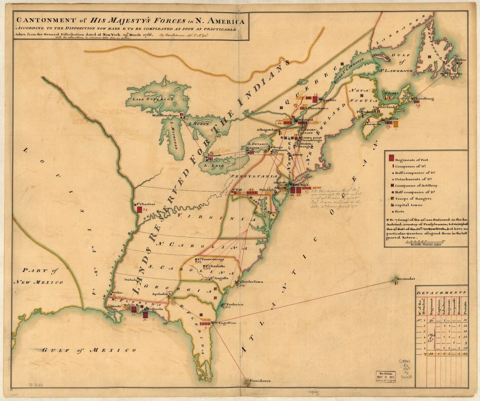
Wartime mapmakers produced an array of images of North America and the West Indies that described previously obscure places and structured attempts by the British to establish authority over them. All of the senior surveyors appointed to map the new territories honed their craft during the conflict and brought a distinctive military eye to the images they produced from 1763 on. Their maps envisioned an empire that, shattered by the War of Independence, never came to be. The fruits of this effort were in fact used to break the empire apart. When war came to North America and the Caribbean, military hostilities disrupted these surveys and ended this great imperial mapping project, as well as the vision of expansive empire that was behind it. Some surveyors in the field were captured and imprisoned by Continental forces, while others were reassigned to map strategic locations in the settled colonies as British commanders prepared their battle plans. Copies of a pocket-sized military atlas derived from these surveys were distributed to officers before they sailed west to invade rebellious colonies.
After the 1783 Treaty of Paris, Britain was forced to abandon the idea of a settler empire that featured a contiguous band of territory spread across the Atlantic Ocean’s northwestern edge. The maps endured, however, as a new foundation for geographic knowledge about America. Even as the vision behind them fell apart, they were transformed into magnificent works of published cartography. In the voluminous printed sheets of The West-India atlas, The Atlantic Neptune, The American Atlas, and other works, images drawn from these surveys presented breathtaking new views of a lost Atlantic world. Imperial surveyors created more images of North America and the West Indies in this single generation than all of those who had taken up compasses, chains, and plane tables in the previous two centuries of British New World exploration and colonization. Repurposing old maps to describe a new nation, Americans reimagined the same images to see an expansive continental empire in which the restrained energies of settler colonialism would be unleashed and redirected toward the west.
The most important recent insight regarding the history of cartography is that maps, far from being dispassionate pictures, are created by people with agendas for how to represent the world. Mapmakers-then and now-shape their images with ideas about who has the right to command geographic space, the uses to which it should be put; and the qualities of the people who inhabit it. The maps discussed in this book are full of such meanings, and their value as sources rests on their richness as cultural as well as empirical objects. It is clear, however, that these maps of diverse and scattered places are like pieces of a vast puzzle whose overarching significance can only be revealed by bringing them together and seeing the body of knowledge they form. Once united, they reveal a coherent British vision of western empire that sought to displace settlers as meaningful agents in favor of a regulated system of colonization orchestrated from London.
A century of engagement with France, Spain, and indigenous peoples in North America and the West Indies convinced British thinkers that their productive and populous colonies faced ruin because they lacked a secure geographic position from which to expand. Although the Seven Years’ War was triggered by contention over which power possessed the Ohio River valley, Britain broadened the meaning of the peace that concluded this conflict by conceiving of a plan to secure the postwar empire along its many unstable frontiers. The prospect that unregulated territories might be assimilated by rival powers convinced imperial officials that they should govern these scattered colonies-from the fishing stations at Newfoundland to the sugar plantations of the Caribbean-as parts of one system. The prewar fear of French encroachment was explicitly about space and who could possess it, yet imperial thinkers also focused on the problem of time and the challenges that stood in the way of reproducing colonial societies, economies, and populations into the future. The violence that surged across every contested imperial frontier between the Glorious Revolution of 1688 and the Peace of Paris underscored the fundamental spatial disorder that threatened the integrity of Britain’s American empire.
Imperial reformers created settlement systems in each of the territories to improve on a prevailing mode of colonization. On the theory that frontiers should be secured before waves of settlers advanced inland from the coast, the army opened corridors of settlement along West Florida’s rivers, stretching between interior forts and Gulf of Mexico port towns. The Board of Trade’s commissioners accused New England merchants of plundering the maritime northeast in search of short-term profits, leaving it unsettled and undefended. As the centerpiece of their plan to take possession of the Gulf of St. Lawrence for Great Britain, they apportioned the entire island of St. John into sixty-seven 20,000-acre townships. The Privy Council formally granted these early modern fiefdoms to metropolitan insiders on the condition that they draw settlers to their lands to inhabit new farming and fishing communities.
The planters of the British Caribbean became a magnificently wealthy elite as they reaped the profits from their sugar estates, monopolized the best lands, and worked slaves to death in brutal conditions. An impartial auction distributed planting land to investors in the Ceded Islands who paid a premium to the Treasury for the opportunity to claim fertile new acres for sugar. Lowcountry planters in South Carolina and Georgia had established powerful family dynasties at the price of overpopulating the southeast with restive African slaves and acquiring far more land than they could cultivate.
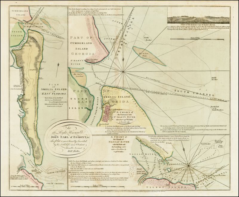
In East Florida, the Board encouraged township proprietors to experiment with indentured servant labor as well as new commodities, and surveyors laid out tracts along the full length of the St. Johns River to organize rapid plantation settlement. To secure the volatile North American Indian frontier, the Board persuaded the king to prohibit unregulated western expansion behind the settled colonies and recognize the territories of indigenous nations. In each of these theaters for reformed colonization, geographic surveys and mapmaking enabled Britain to begin settling new colonies without having to delegate the task to a cadre of autonomous founding colonists who, if history was any guide, would shape the trajectory of development to suit their own interests regardless of the consequences.
What these maps mean depends on what we think they are. Among other things, these maps were the source materials from which commercial mapmakers engraved images for publication and broad public consumption; they were a form of discourse composed to persuade viewers of an ideological message, especially about claims of sovereignty; they established routes and relationships across space as they recorded the findings of organized journeys of conquest, exploration, and survey; they marked abstract boundaries across visible landscapes; they terrified and tantalized, making fears and aspirations palpable by giving them geographic form; they were technical documents produced by the state to gather instrumental knowledge of places in which it had a material interest, particularly regarding defense and landownership; and they served as patronage performances drafted by their makers to demonstrate their expert knowledge of place in hopes of preferment.
Above all, these maps represented knowledge to demonstrate authority over American places. This book is not, strictly speaking, about the making, dissemination, and consumption of maps; it is, rather, a spatial history of empire that focuses on maps because they enabled British officials to see distant lands in high resolution after the Seven Years’ War, a capacity that emboldened them to take command of new colonial territory directly from London in new ways—and with new purpose.
The Board of Trade was a comparatively small, undernourished, but influentially placed committee, which oversaw British America by generating and controlling information. This challenge of exerting power outward, across vast reaches of space, preoccupied Britain’s army and navy as well, both of which developed a deep administrative infrastructure in the second half of the eighteenth century that mobilized people, resources, expertise, and technology to project force into the Atlantic Ocean and around the world. Historians have failed to appreciate the scope of the Board of Trade’s plan, in part because few scholars have seen the voluminous body of maps it produced gathered in one place, which by its sheer volume and breadth testifies to the seriousness of Britain’s intentions.
This tendency to dismiss imperial reform also reflects a number of assumptions about American colonists and British officials that this book challenges. Historians of the imperial school have generally regarded new colonial regulations as inoffensive and necessary for the proper administration of a stable overseas empire. Those who have argued that colonial protest emanated from an unsubstantiated fear of centralized power, steeped in an eccentric strand of radical English republicanism, have likewise emphasized the benign intentions of Britain’s American policies. This view underestimates not only how provocative these policies were to colonial sensibilities but also how unprecedented they were as attempts to extend the power of a central government into the economic lives of its subjects.
Although Americans were famously undertaxed compared with Britons at home, they had generally enjoyed the freedom to claim land where they chose and develop it as they wanted, and this landed liberty was at the center of their identities as settlers and subjects. Britain stepped between colonists and American land in the years before the American Revolution by prohibiting the legitimate ownership of interior tracts, imposing new costs and restrictions on obtaining grants in the new territories, favoring metropolitan insiders over American elites in the distribution of new lands, and threatening to extend such oversight to the settled colonies. Moreover, the explanations behind the royal proclamations, acts of Parliament, and modes of enforcement that colonists objected to, voiced by senior officials as well as writers who published their commentaries in widely circulating pamphlets, stigmatized colonists as selfish, reckless, and obstinate, and dismissed what the Americans regarded as their greatest historical accomplishment—the occupation and improvement of so much land with so many people—as a looming disaster for Britain. The imperial state’s intrusion into the process of colonization and the language used to justify it denigrated colonists’ stature within the British Atlantic world and threatened their future as meaningful agents of empire.
In their attempts to chart the complex struggles for power among shifting factions in eighteenth-century Britain, historians have down-played the Board of Trade’s role in imperial reform. They have focused on the Earl of Halifax’s robust leadership of the Board in the 1740s, capped off by the settlement of Nova Scotia, as the apogee of its influence. The revocation of its power to appoint colonial officials, as well as the failure of Halifax’s campaign to secure a seat on the Privy Council for its president, seemed to indicate its decline into irrelevance. Using appointments to high offices to track the winners and losers in this roiling pageant of competing patronage networks and shifting political alliances ignores the practical power that came with collecting information, determining its meaning, and articulating policies based on expert knowledge. Although many of its initiatives failed to bear fruit, the Board exercised such power both through its constant communication with colonial officials over mundane as well as extraordinary affairs and through its many reports and proposals to the secretary of state for the Southern Department and the king-in-council, many of which gained approval with minimal revision.
By the turn of the 18th century, the Board of Trade was codifying information that flowed from the outer reaches of a vast, discontinuous maritime realm on which most believed Great Britain’s fortunes depended. As it calculated the stunning rise in the value of overseas colonies to national wealth, it assumed a place at the center of a nexus of data about empire that gave its recommendations enormous weight in councils of state. The Board of Trade’s ability to use this command of vital information about the Atlantic world to effect change oscillated over the course of the eighteenth century with the outbreak and negotiated conclusions of three major wars. It was the “peacetime consigliere” of Britain’s Atlantic empire, declining in influence during wartime but rising in stature after the conclusion of conflicts, when it came time to organize territorial gains and address the vulnerabilities the fighting exposed. Few historians have questioned the view that the Board generated many words but few meaningful actions when it came to the colonies. I contend that not only did the Board of Trade matter, but its new conception of America in 1763 changed the course of empire.
Because British ministries changed hands so frequently between 1762 and 1783, the resulting political turmoil generated inconsistent legislative policies toward America, which lacked any coherence. Political leaders rose and fell in brisk succession during this tumultuous period. The different heads of short-lived ruling coalitions—Bute, Grenville, Rockingham, Chatham, Grafton, North, and Shelburne—along with their allies and followers, expressed, in word and deed, different views of taxation, regulation, and the proper response to increasingly intense and coordinated colonial protests. Despite this range of stances—some sympathetic to American concerns, others hostile to them—all agreed on the necessity of establishing new colonies with greater metropolitan oversight, securing America’s economic and political dependence on Great Britain, and forestalling any moves toward independence.
A number of prescriptions featured in the Board’s plan in 1763—including the jurisdiction of the trans-Appalachian northwest, the administration of commerce with Native Americans, and the deployment of soldiers in remote forts and garrisons—changed over this period. Much of the Board’s work was transferred in 1768 to the new secretaries of state for the colonies, the Earl of Hillsborough (1768-1772) and the Earl of Dartmouth (1772-1775), but these were the same men who had headed the Board for much of the 1760s and who continued to see America through the lens of the Board’s long-standing mission for reform.
Even when the king named George Germain colonial secretary in 1775 to manage Britain’s war against America from the Colonial Office, surveyors continued to draft maps and charts, and new colonists obtained land in the new territories on restrictive terms. Although disrupted by the war, the core vision first articulated by the Board of Trade under the Earl of Shelburne in 1763 persisted until Shelburne, as prime minister, oversaw the negotiations that ended the War of Independence twenty years later.
Mapmaking created images of American places that represented what those places were, how they came to be, and what they should become. Although maps cannot do justice to the full historical experiences of European, African, and indigenous peoples who inhabited the territories that were formed into colonies at the frontiers of this empire, understanding Britain’s surveys of them helps us view these places less as fractured, underpopulated frontiers and more the way the Board’s commissioners saw them when they first sketched British America’s new boundaries.
By joining these disparate places together on a new map of empire, the British authorities imagined a way to define and secure them as growing dependencies. These maps were designed to make distant places visible and bring the process of their settlement and development directly within the purview of officials in London. These schemes for new colonies, which could bind the whole of the British Atlantic system into a new order, rested on the idea that this space could be revealed, and thereby administered, by mapping it.
Modern states have used technologies of information gathering to implement broad reformist schemes, from harvesting forests to building cities. To represent the nation in ways that prepared it for regulation, taxation, and social control, technocrats reduced its complexity to salient elements that could be managed by sweeping policies. The “crowning artifact of this mighty simplification,” James C. Scott has argued, “is the cadastral map,” a document that lists landowning inhabitants and displays the bounds of their individual properties.
To make such maps of an entire nation legible required the elimination of extraneous detail as well as significant abstraction. This resulted in a restricted view of land and people that saw them solely in terms of the state’s interests. Socio-ecological systems became board feet of lumber, bodies to be housed, and acres to be taxed. Broad official consensus about the soundness of the aims of rational control and human improvement gave these visionaries access to considerable resources and the power to use them. Their lofty schemes, however, failed to account for the importance of varied and particular conditions, and their techniques of information gathering and analysis ignored the local knowledge of place that had been built up at the scale of human experience.
Great Britain’s attempt to map the new territories of its American empire—perhaps the first effort to grasp the potential of using geographic information to enact a new kind of colonial rule—anticipated the totalizing schemes in which modern states put such information to use. In the eighteenth century, however, Britain lacked the resources to gather data comprehensively as well as the administrative capacities to store, analyze, disseminate, and access the information it did accumulate. And it proved unable to reconcile ideas of place that drove policy at the broadest scale with the particular information its surveyors returned, especially when these particularities conflicted with the general vision. Britain enlarged its command of fiscal resources, forged a political consensus about the need to improve colonial administration, and demonstrated the ability to project military force to the ends of the earth, but even this most powerful of early modern states lacked the capabilities of its modern successors to transform whole regions to exacting new standards.
As a result, the attempt by the Board of Trade to control colonization from London through the rigorous representation of land and space differed from these twentieth-century social experiments in a number of ways. The Board’s commissioners shared the precept of early modern political economy that the state lacked the power to alter fundamental interests, which drove behavior from a deep structural level of society that was, to a large degree, beyond its reach. Instead of forcing an idealized way of work and life on British subjects abroad, the Board imposed conditions on the granting of the king’s conquered and ceded lands, guiding colonists by these restrictions to act in ways that it believed would benefit Britain. In this way, its colonization schemes sought to create a new relationship between the settler and the state, which was an extension of the negotiated governing practices that had shaped colonial America from its inception. In the end, it depended on colonists to act in ways approved by the state.
Britain’s effort to map America was also profoundly empirical, as concerned about revealing the distinctive qualities of places as it was in creating generalized schemas. Such practical empiricism was part of a long tradition of English inquiry that respected tried-and-true methods, particularly in agricultural science. As applied to the challenge of mapping America, this openness to vernacular knowledge also reflected the utter lack of durable information about the places under scrutiny. Instead of a confident, top-down imposition of a rigid technocratic order, Britain’s scheme for the new colonies was highly prospective and rested on assumptions that the surveys were commissioned to examine. Britain launched its plan before it possessed the knowledge needed to execute it, leaving it open to new conceptions and prone to failure.
The War of Independence fatally disrupted the surveys and the schemes they supported only twelve years after they began, making it difficult to assess them. In this brief time, Britain negotiated a continental boundary line with Native American nations, oversaw the settlement of nascent colonies of fishermen and farmers on St. John Island and planters and slaves in East Florida, opened routes of river and coastal navigation, established a sugar plantation economy in Grenada, and occupied a number of strategic military sites. At the same time, it failed to prevent squatters from encroaching on indigenous lands, relinquished control over Indian commerce to provincial governments, fought a bloody war of extermination to a stalemate against St. Vincent’s Black Caribs, struggled to establish a viable settler society in West Florida, and withdrew soldiers from a number of recently occupied forts and garrisons in the North American interior. Judged against the Board of Trade’s lofty vision, these disappointing outcomes resulted in part from the outsized ambitions of an overreaching state.
Britain succumbed to the predictable hubris of modernizing states, so confident in their technologies of governance that their expectations for order almost inevitably fracture when faced with unforeseen contingencies, especially when people resist schemes that they believe aim at their subjugation. Its struggle to impose a particular spatial order on America generated its own undoing, which went beyond a contribution to the general discontent that drove colonial protest. Like Narcissus, the British state beheld the geographic images it produced and was beguiled by them. In fact, George III became so enamored of the maps dispatched from America that he plundered Whitehall offices to stock a personal archive, now the King George III Topographic Collection at the British Library. Ambitious officials soon learned that making elegantly drafted presentation copies of surveyors’ manuscripts was a good way to gain an audience before the king. But like the monarch surrounded by his maps, which seemed to open even the most remote coasts to view, Britain failed to grasp America’s vastness and the enormous distance between the general scale of sovereign claims, on the one hand, and the particular scale of land as it was occupied, on the other.
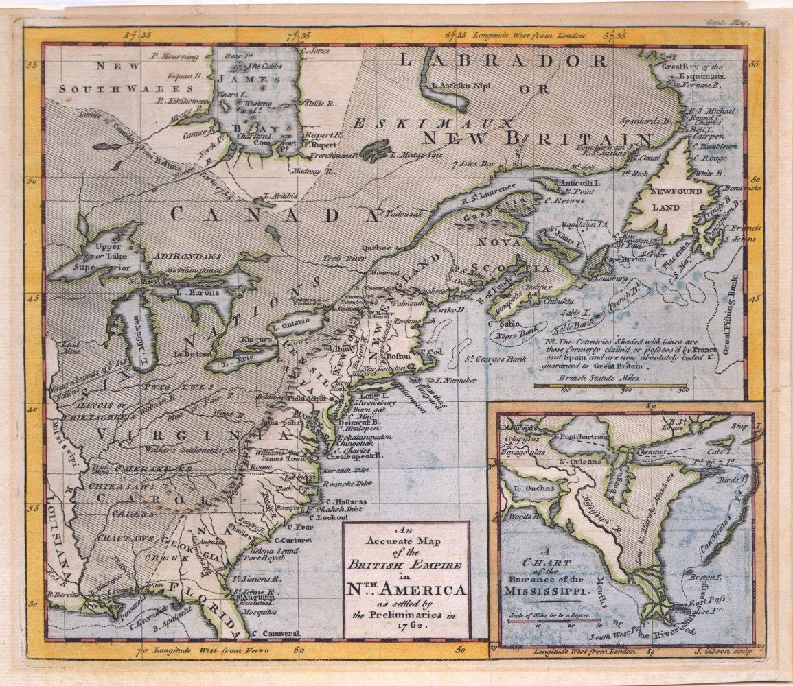
The “new map of empire” is both a way to describe this plan to reform British America and a real cartographic object: the first map the Board of Trade used to visualize it. Robert Sayer’s Fleet Street press produced, in all likelihood, hundreds of copies of Emanuel Bowen’s An Accurate Map of North America Describing and distinguishing the British, Spanish and French Dominions on this Great Continent According to the Definitive Treaty Concluded at Paris February 10, 1763. The Board purchased one of these, marked it up to illustrate the geographic plan it proposed, and annexed the image to its official report to the king, which it submitted on June 8, 1763. This map can be retrieved at shelf-mark MR 1/26 from its sturdy metal cabinet at the National Archives of the United Kingdom at Kew. Across its surface, lines and washes of color cut across the latitudes that defined original colonial charters and prewar provincial boundaries. These annotations marked spaces along the Atlantic watershed to which mainland settler societies were to be confined, compressed the formerly expansive provinces of New France and Spanish Florida, highlighted certain places earmarked for intensive colonization, and set off others as off-limits to legal settlement. The Board of Trade’s commissioners made visible a transatlantic system of political economy on this map and assumed that it could take hold within the spaces the map represented.
As geographers who have wrestled with the problem of scale have recognized, maps tend to perpetuate the false notion that scale is a natural property of space. The idea that cartographic space exists absolutely to contain territories, populations, economies, and societies made it particularly attractive to imperial reformers, who sought to establish a new standard of metropolitan command over the colonial periphery. Part of the value of cartography for administering empire was that its absolute scale of measurement contains a clear hierarchy of relationships that shows precisely how smaller places are embedded within larger ones. But this idea of space as infinitely reconcilable is an illusion. In reality, the nature of space changes at different levels of resolution.
Those who neglect this characteristic of scale—like Britain’s centralizing, mapmaking, senior colonial officials—and “use data at one scale to make inferences about phenomena at other scales,” commit what geographers call a “cross-level fallacy.” When it assumed that its macro-level judgments about economy and society for each of British America’s regions would persist at the micro level of the individual tract of land, the Board of Trade committed the cross-level fallacy known as “scaling down.” Benjamin Franklin ridiculed Josiah Tucker for making this mistake when the famed political economist proposed that Britain clear a strip of land a mile wide across the North American frontier to prevent Indian attacks, as if such an impossible task could be performed as simply as drawing a line across a paper map.
When it called for the mapping of small spaces at high resolution and presumed that this intimate knowledge would confer a general under-standing over larger regions, the Board fell into the converse error of scaling up. Before 1763, few maps captured the detailed sense of space at the scale at which inhabitants experienced American places. Their working knowledge can be glimpsed from time to time in references that reveal the boundaries they drew between places of security and danger, prosperity and poverty, and civility and savagery. Most took this lived geography for granted and did not bother to describe, much less explicitly draw, these mental maps, which they carried with them to impose a sense of place on their surroundings. The spatial pattern by which places might be characterized by these opposing values shifted from generation to generation, as settlement expanded, violence flared and subsided, economic activity intensified, and populations grew. Spatial sensibility in early America was never locked in place the way that restorations of historically preserved houses might lead us to believe.
Colonists expanded the territorial reach of their provinces by developing regionally rooted systems of agriculture, trade, and settlement. The resident elites who governed these societies controlled the legal process by which their colonies grew, establishing new jurisdictions and opening the territory they contained to acquisition through warrants, surveys, grants, and sales. Because land was the ultimate source of wealth in colonial British America, this creole class of American-born leaders, who knew these geographies by experience, devoted itself to acquiring and mastering a body of firsthand knowledge about the landscapes that contained this real property. Britain adopted a plan for American empire in 1763 at the general scale of the continent. In place of an open-ended process of social development, it imposed a desired end point for growth: colonies fully organized to contribute commodities to the Atlantic economy derived from the distinctive resources of their environments. To make this general plan a reality, the Board of Trade initiated intensive and extensive new surveys of American coasts to generate firsthand knowledge of new colonial spaces at much higher resolutions. But it underestimated the difficulties of scaling down this vision to the level of settlement, where settlers took possession of land, tract by tract, by planting it.
Maps were a technology that permitted Britain to direct the settlement and development of new territories from a distance. Surveys and maps at the high-resolution scale of the individual tract simulated direct access to the land as it was seen by those who lived on it, revealing the local character of its terrain, the boundary lines by which landowners carved it up into a “private property mosaic,” and the ways in which these places joined together to form a regional pattern of settlement.
Particularly after 1748, the Board of Trade demanded new descriptive reports of natural resources, new statistical accounts of trade, and especially new maps that depicted the landscape at this salient scale for colonization, from one-half to two miles to the inch. With such precise accounts of British America at its disposal, the Board laid plans to supplant creole expertise. Mapmakers attempted to produce credible facsimiles of the world, and this effort produced an illusion of direct correspondence between cartographic images and the underlying spaces they represented. Sophisticated eighteenth-century map viewers scrutinized such claims of accuracy, critiquing maps they found to have errors and pointing out their discrepancies with known places. Colonizers nevertheless relied on maps to know the places that they traversed, governed, and defended. Without the representational credibility of their maps, the colonial enterprise in which they were engaged, resting as it did so fundamentally on imagining, distributing, and possessing distant land, would have seemed as uncertain as it in fact was.
.