By artfully illustrating the boundaries of colonial powers, mapmakers in the 1700s helped define what our New World would become.
-
September 2022
4 years ago By Edwin S. Grosvenor Volume67Issue4
Editor’s Note: Neal Asbury is an entrepreneur, map collector, and host of a nationally syndicated radio talk show. Jean-Pierre Isbouts is a professor of history and an award-winning screenwriter and film director. They are the authors of Mapping America: The Incredible Story and Stunning Hand-Colored Maps and Engravings that Created the United States, in which portions of this essay appeared.
During the 18th century, mapmakers, surveyors, and cartographers of the English colonies in America took on a new role. Up to this point, creating maps of the American continent had been an art as much as a science, designed to appeal to a broad public on both sides of the Atlantic Ocean. For European buyers, especially, a map of America was a glimpse of a faraway and exotic land, populated by Indians and fearsome animals amid a wild and exuberant landscape that had yet to be tamed by human hands.
But this changed as the conditions on the ground shifted, and life for the colonists became more perilous. The reason is that, for much of the 17th century, the American colonies had been shielded from the great conflicts that scourged Europe. True, there were clashes between French, Dutch, English, and Spanish colonists, but most of these contests had to do with local boundaries or trade, rather than the big political matters that vexed the European powers some three thousand miles away. But, as the American colonies matured into a powerful entity in their own right, they were bound to be sucked into a string of conflicts that roiled Europe throughout this period.
In 1743, King George II of Britain decided to see what spoils he could get for himself. Before long, the English and French armies met at the cataclysmic Battle of Dettingen, which ended in a heavy defeat for the French. Of course, this called for revenge, and so the French generals came up with a rather daring gambit: to invade Great Britain and restore a Catholic king to the throne. But on the night the French fleet was about to sail, a violent storm lashed the ships’ berths, ripped their sails, and toppled their masts, so the invasion attempt was abandoned. Thus repulsed at sea, the French continued to fight on land, one battle after another, while vast sums were spent and not much of anything was accomplished.
The news that France and Great Britain were locked in a fierce European war soon reached American shores. Here, it once again inflamed the long-simmering tensions between the colonists of New France and their opposing numbers in England’s Atlantic colonies. These tensions had often resulted in small clashes here and there, but never an all-out war. Now, however, many of the American colonies rallied to the colors, filled with pride in their English heritage and eager to teach those annoying French a lesson they’d never forget. The English militia, filled with righteous anger, soon settled on a perfect military objective: to capture the French fortress of Louisburg on Cape Breton Island, just off the coast of Nova Scotia. After heavy fighting, they succeeded in investing the citadel.
What this strange conflict did achieve was that, for the first time, a continental war had spread to North America, with both French and English colonists rushing to the defense of their homelands. And, while in Europe, the war finally came to an end with the Treaty of Aix-la-Chapelle of 1748, in North America, the fuse of European enmity continued smoldering. That was particularly true for Massachusetts, which had lost eight percent of its male population in the war and where news of the return of Louisburg to France was met with outrage. Massachusetts and other colonists decided to bide their time and wait for a spark that would once again prod the colonies to all-out war. That spark was not long in coming.
In 1749, the governor of New France, Roland-Michel de la Galissonière, was fed up with repeated attempts by British traders to trespass in the Ohio Valley, which — on paper, at least — was considered part of Nouvelle France. Those interlopers sought to steal the fur trade with local Indians from under the noses of the French. In response, de la Galissonière dispatched an expedition of some two hundred French marines into the valley, more as a show of force than for actual combat, in the hope that this would rally the Indian tribes to the French side and forever end any contact between them and English colonists.
Alas, the campaign did not have its desired outcome. “All I can say,” wrote one French commander, Pierre Joseph Celoron, upon his return to camp in Montreal, “is that the Natives of these localities are very badly disposed toward the French and are entirely devoted to the English. I don’t know in what way they could be brought back.” Soon thereafter, news of the French maneuvers in the Ohio Valley reached the French and British capitals and once again spurred a call to arms. Thus began the French and Indian War, a conflict that would forever change the face of the North American continent.
To understand this, we should always remember that, while French and English colonists had never seen eye to eye, they nevertheless shared some solidarity, some sense of a common cause. They were Europeans, surrounded by hostile natives in a foreign land, with wild animals, unusual climate cycles, and impenetrable natural barriers. In the early days, these colonists might have been rivals, but never sworn enemies, not foes to the death. The war of 1754 changed that. Men on both sides rushed to arms to defend their homesteads, their lands, and the boundaries of their colonies.
That meant that now more than ever, an exact definition of those boundaries became very important, for it was along these frontiers that the battles would be fought. Not for nothing did the French call the conflict la Guerre de la Conquête, “the War of the Conquest.”
Another crucial factor in this conflict was knowing which Native American tribes resided in the borderlands and what side they were likely to take in the conflict. This was extremely important because, at the outbreak of war, the English colonies were protected by just five British companies of one hundred men each - a pitiful number. Alliances with neighboring tribes were therefore essential to bolstering their defenses in the battles to come.
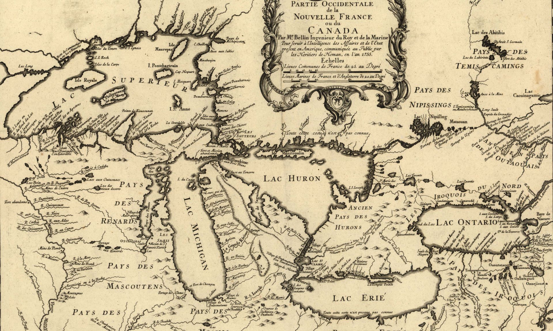
Jacques-Nicholas Bellin’s Detailed Map of the Western Part of New France, for example, was created to show that the French garrisons of the Great Lakes could easily be overwhelmed by the vast numbers of the Huron, Renard, Mascouten, Iroquois, and Erie tribes that surrounded them. Indeed, this map was instrumental in prodding the local French commanders to conclude treaties with most of these nations, except the Iroquois, who tended to throw in their lot with the English colonists, who also made common cause with the Cherokee and the Catawba.
For nine years, the war raged up and down the spine of New France, from Newfoundland in the north to Virginia in the south, where the local Virginia militia was led by a 22-year-old officer named George Washington. Initially, the war did not go well for the English colonists. The French adroitly used their Indian allies to outwit the English forces, and several plans by the British commanding general, Edward Braddock, came to naught.
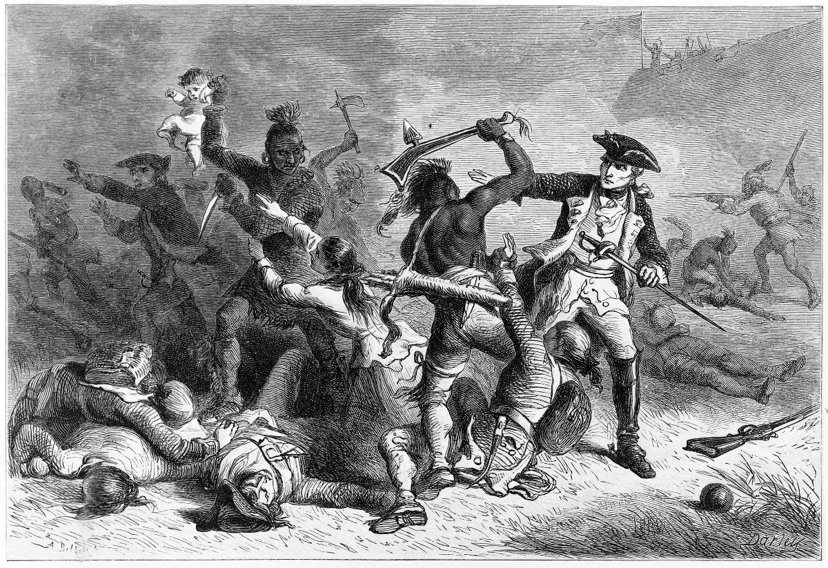
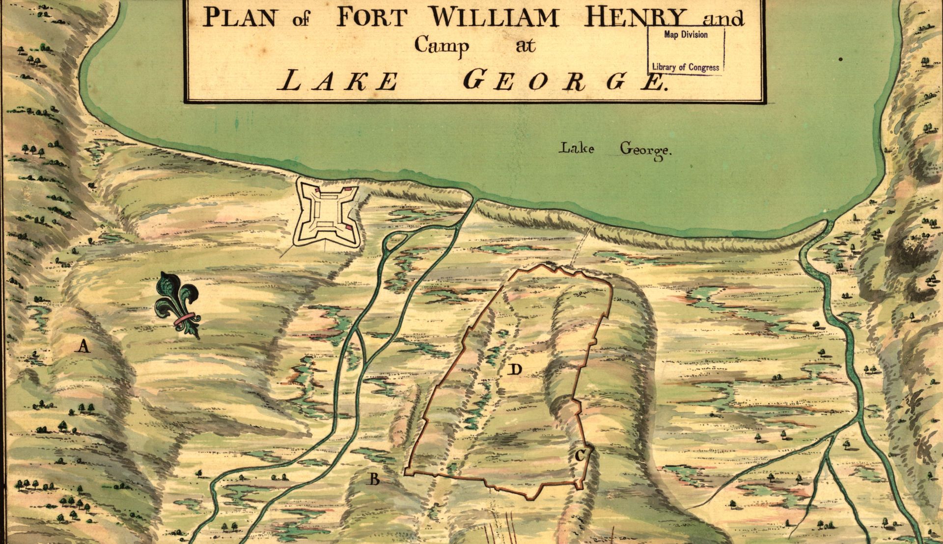
Then, in 1757, the French siege of Fort William Henry, located on the border between New York and Canada, resulted in an unspeakable massacre. After the fort’s occupants agreed to surrender, the Indians rushed in and scalped the English soldiers, while the French looked on and made no effort to stop them. Women, children, and servants were taken as slaves.
This bloody event marked the nadir in the relations between the French and English in America. For years to come, the cry “Remember Fort William Henry!” would stir English hearts against all things French. It would also inspire the 1826 novel The Last of the Mohicans by James Fenimore Cooper, which, between 1912 and 1992, would lead to a number of film adaptations, the last one starring Daniel Day-Lewis.
The British Whig government, prodded by William Pitt, was finally galvanized into action. Britain had already dispatched six thousand troops, but Pitt judged, correctly, that the French could be defeated only by striking at the heart of New France: the towns of Montreal and Quebec. Both sites were extremely difficult to attack because of their geographical location and the harshness of the Canadian winter. Any military-campaign leaders would therefore need to know the lay of the land in exact detail and have the best possible grasp of the field. This fact changed the nature of mapmaking in America. The art of cartography, borne of commercial and colonial interests, now became an instrument of war.
London as the New Center of Cartography
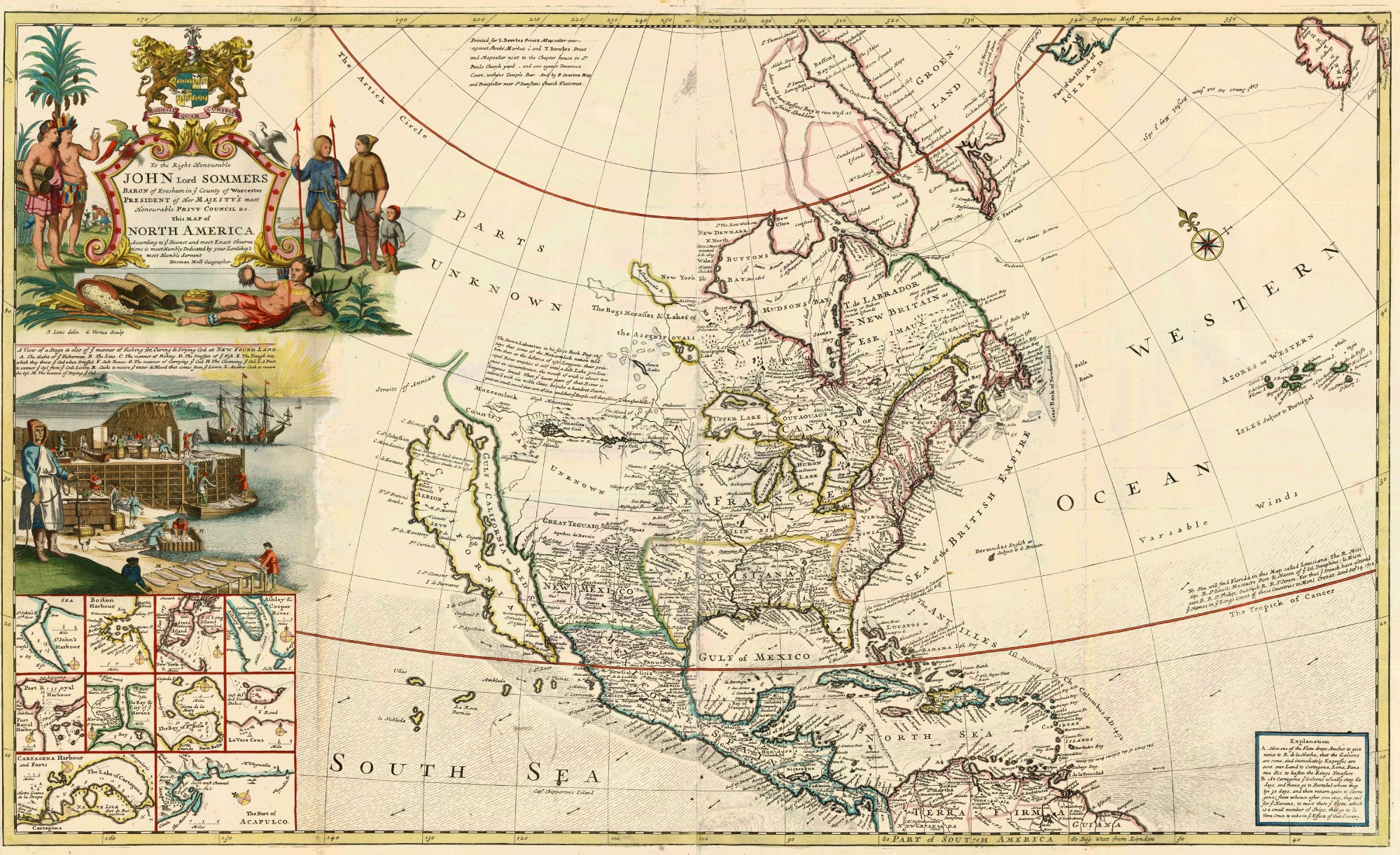
No one understood that better than the mapmakers in London, a city that, by the eighteenth century, had succeeded Holland as the center of global cartography. In fact, that is why, in 1679, a 24-year-old cartographer named Herman Moll decided to pack up his belongings and move to the British capital. In time, Moll, whose nationality is not known, became close friends with luminaries such as the navigator and rumored pirate William Dampier, the scientist Robert Hooke, and the physicist Robert Boyle, while Moll was making a living in various engraving shops.
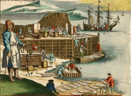
He published his first major work, A System of Geography, in 1701. This was followed in 1715 by his magnum opus, an atlas of thirty large folio maps entitled The World Described. One of these is the map that would bring him lasting fame — This Map of North America According To Ye Newest and Most Exact Observations — also known, more prosaically, as the Codfish Map. As it happens, the map includes a pretty inset engraving of fishermen catching and drying cod along the shores of Newfoundland.
There was a good reason for that: the codfish industry was the second-largest source of revenue from British America after the trade in Virginian tobacco. Moreover, fishing rights were major points of contention between the French and the British, so the identification of fishing waters had strong political overtones, as well.
Moll’s maps testify to his attention to precision and detail; like many German maps of this era, they are distinctive for their elaborate cartouches, executed with Baroque flourishes and insets. Indeed, most German cartographers were devout Lutherans who dedicated their maps to the glory of God, as composers such as Johann Sebastian Bach did with their musical works. But few of these maps offered radically new insights. After all, the Germans were not explorers themselves. They relied on maps made by others, sometimes enhanced by reports from seafarers. For example, the Codfish Map includes the mythical Long River that was believed to connect the Mississippi River with points in the far West. The myth of the Long River was based on observations by Louis-Armand de Lom d’Arce, Baron de Lahontan, a notorious French adventurer and fraudster who claimed to have discovered this waterway in the 1690s.
Things changed in the 1740s, not only because of the ongoing contests with the French, but because Great Britain was suddenly gripped by fear of a Jacobite rebellion in Scotland, which aimed to restore the Stuart line to the English throne. In response, the British Ordnance Survey commissioned a series of detailed maps of the country, directed by the cartographer William Roy, to aid in the defense of the realm. As military maps, they were never published, but they did raise the quality of the underlying data, the accuracy, and the detail of geographical features to an entirely new level. The growing threat of France, including the very real danger of an invasion, added further urgency to this new type of mapmaking. There were no longer any cartouches or flowery ornaments in these maps; instead, the focus was on representing the ground as faithfully as possible.
Similarly, in 1748, the British Board of Trade and Plantations became concerned about the vulnerability of Pennsylvania and Virginia. The board ordered a new set of maps that would clearly chart these two regions, with a detailed depiction of towns, roads, and topographical features such as rivers and streams. For the Virginia map, the board chose two experienced surveyors, Joshua Fry and Peter Jefferson, whose son Thomas would later become a leader of the American Revolution. The first edition of these maps was delivered in 1752 and finally completed in 1755, after the outbreak of the French and Indian War.
In its final form, the map documented the living space of four hundred thousand colonists (both whites and slaves), and the heartland of America’s tobacco plantations. The map would later play an important role in the Revolutionary War, due to its detailed depiction of Virginia’s river systems; it was the first map ever of the state’s four principal rivers and their tributaries.
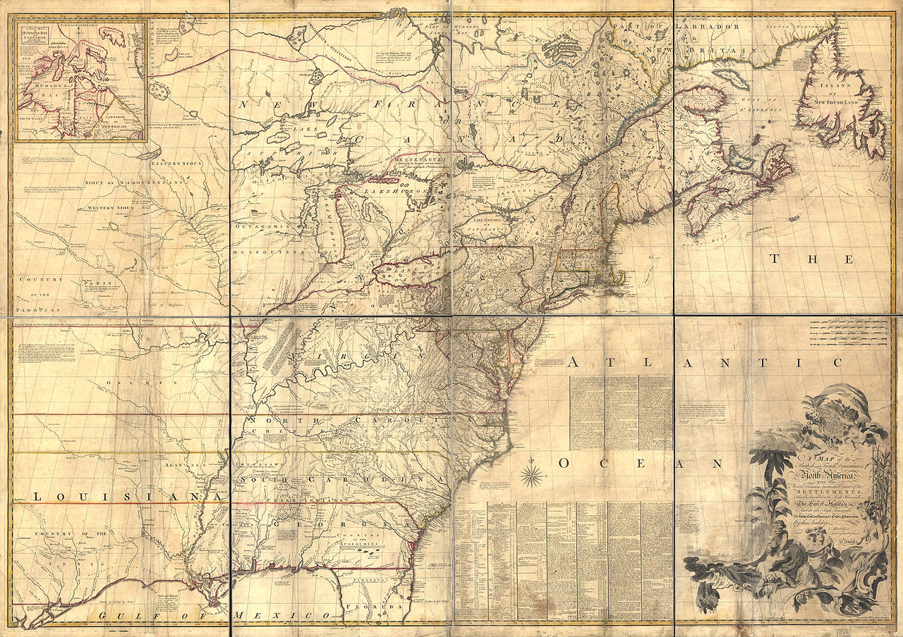
A similar map, though on a far greater scale, was published that same year by John Mitchell under the title L’Amérique Septentrionale avec les Routes, Distances en miles, Villages et Etablissements François et Anglais (“North America with the Roads, Distances in miles, Villages and French and English Settlements”), thus clearly revealing the military purpose of the project. Not surprisingly, Mitchell’s map would become the single most important artifact for debating and settling treaty disputes in the eighteenth and even nineteenth centuries.
Like Joshua Fry and Peter Jefferson, John Mitchell formed part of a new class of cartographers. These were men who were born in America and had arrived at their profession along circuitous paths that, as with their counterparts in Europe, often involved stints as natural scientists, globe-makers, surveyors, physicists, and other scientific endeavors. In the eighteenth century, to be a mapmaker was a gentleman’s calling, and it was informed by a whole range of disciplines. The word dilettante did not have the pejorative meaning that it has today.
In Mitchell’s case, that meant that, although he was born and raised as the son of a wealthy plantation owner in Lancaster County, Virginia, he was soon dispatched to the University of Edinburgh to get his degree. By 1735, he was back in Virginia and practicing as a physician, while devoting his spare time to his love of botany. In 1746, Mitchell made the decision to return to the more temperate climate of England. Unfortunately, the War of the Spanish Succession was still raging, and the ship he was on was intercepted by French pirates. All his belongings were taken away, including his coveted botanical samples, so he arrived in London virtually penniless.
But he was able to quickly develop a network of contacts. In 1748, he was elected to the Royal Society, a singular honor that placed him at the center of British intellectual endeavor. The official document that nominated him to this august body went out of its way to cite his expertise as someone “who, from his long residence in Virginia, from his great application to the Study of Natural history, especially Botany, is very well acquainted with the vegetable productions of North America.” And not just its vegetable cultivation, for Mitchell’s youth in Virginia had given him a keen understanding of the geography of the Eastern Seaboard, as well as the political tug-of-war that was taking place at the borders of the English colonies.
The Royal Society connection brought him into contact with an influential nobleman named George Montagu-Dunk, the Earl of Halifax. As it happened, Halifax was also the president of the Board of Trade that was focused on creating a new class of maps of all the strategic territories under British control. It was only natural that this nobleman would share his concerns about the reliability of existing maps depicting England’s American colonies, given the different administrations and the patchwork of surveys that had produced them. What was needed, Halifax argued, was a complete and thorough map of all of English North America, executed with the same level of scientific detail throughout. Mitchell, whose personal brush with French aggression still rankled, was only happy to oblige.
Modern historians have puzzled over the choice of Mitchell instead of more experienced cartographers who could be found in London by the dozens, but here, as in so many other cases, the British sensitivity to class undoubtedly played a role. Mitchell was a member of the Royal Society by virtue of his work as a physician and botanist, not as a cartographer, and that gave him a leg up over his competition. What’s more, by commissioning Mitchell rather than approaching the cartographers of the British Admiralty, Halifax could keep full control of the project — and claim credit if indeed it proved successful.
Of course, as an amateur cartographer, Mitchell did not have access to any new data, other than what had been published in the years before. This is where the commission by Halifax made all the difference. The board was ordered to provide Mitchell with all of their latest charts, surveys, and other data, including the map previously drawn up by Fry and Jefferson. Officers of the board even sent letters to all the colonial governors in America, ordering them to provide pertinent geographical data and survey maps to Mitchell forthwith.
The result of this effort is an artifact of truly awesome proportions and detail. While much of the territory west of the Mississippi is left indistinct, as was typical at the time, the Eastern Seaboard is documented with a level of detail far beyond anything that had been published before. Of course, the Mitchell Map deliberately favored the British side in interpreting areas of questionable ownership, just as French maps of the era tended to diminish English possessions. Interestingly, this did not prevent Georges Louis Le Rouge from republishing the map in French!
The great irony of the Mitchell Map is that an enterprise designed to protect British interests in North America would ultimately become the most important cartographic instrument in the pursuit of American independence. For both sides of the American Revolutionary War, Mitchell’s map would serve as the defining reference for the field of battle. Of invaluable importance during the conflict, this would also serve as the principal reference during the negotiations of the Treaty of Paris, which in 1783 ended the war and sealed the birth of the United States.